

Grade upto college level General Physics
The navigator of an oil tanker uses the satellites of the Global Positioning System (GPS/NAVSTAR) to find latitude and longitude; see Fig. These are 43036’25.3” N and 77031’48.2” W. If the accuracy of these determinations is ±0.5”, what is the uncertainty in the tanker’s position measured along (a) a north-south line (meridian of longitude) and (b) an east-west line (parallel of latitude)? (c) Where is the tanker?
The navigator of an oil tanker uses the satellites of the Global Positioning System (GPS/NAVSTAR) to find latitude and longitude; see Fig. These are 43036’25.3” N and 77031’48.2” W. If the accuracy of these determinations is ±0.5”, what is the uncertainty in the tanker’s position measured along (a) a north-south line (meridian of longitude) and (b) an east-west line (parallel of latitude)? (c) Where is the tanker?


 0.5’‘ of an arc with respect to the circumference of the Earth is
 0 =
0 = 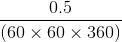
 0.5S
0.5S




